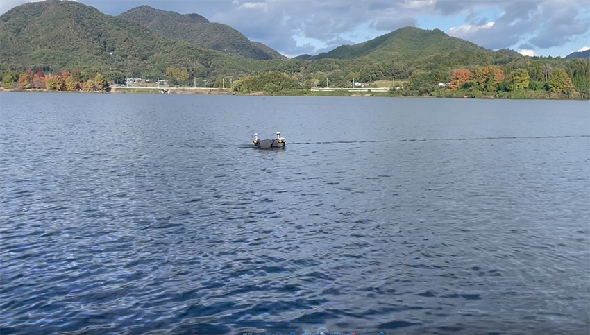
FURUNO (Headquarters: Nishinomiya, Hyogo Prefecture; President & CEO: Yukio Furuno) conducted a successful demonstration of the FBUSV-1 autonomous drone boat equipped with multibeam sonar for efficient sediment volume measurement and 3D mapping at dams managed by Hyogo Prefecture's Civil Engineering Department.
 Demonstration Test
Test Date
November 6, 2025
Objective
Hyogo Prefecture's Civil Engineering Department manages 21 dams throughout the prefecture, conducting sediment surveys every 1-2 years. Current methods use single-beam sonar and weighted lines, calculating sediment volume through average cross-section methods. However, recent challenges include labor reduction, cost savings, more accurate shape measurement, and DX transformation of survey methods. This demonstration aimed to address these challenges using FURUNO's FBUSV-1 autonomous drone boat.
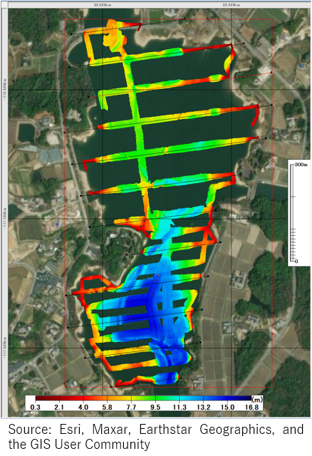
Survey Method
The survey followed previous measurement lines (100m intervals) crossing the dam. The multibeam sonar used provides wide measurement coverage, enabling complete dam coverage with fewer survey lines and more accurate sediment shape assessment.
Comparison with Conventional Methods
|
Single-beam |
Multibeam Sonar (FBUSV-1) |
| Setup/Removal Time |
2.5 hours |
0.5 hours |
| Survey Time |
3 hours |
2 hours |
| Survey Accuracy |
○
2D measurement limits precision |
◎
High-precision 3D measurement
(Multiple beams vs single beam) |
*Single-beam time data calculated from 2024 survey results
This demonstration achieved significant labor reduction in pre- and post-survey operations while enabling precise autonomous navigation along survey lines without manual vessel operation.
Equipment Used
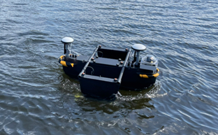
Multibeam Sonar-equipped Autonomous Drone Boat "FBUSV-1"
This prototype bathymetric survey model features a multibeam sonar mounted on FURUNO's compact autonomous drone boat currently under development. Designed as an "entry model" with "compact and lightweight (approximately 25kg)" concepts, it serves as an alternative to conventional survey methods. FURUNO is proceeding with NETIS (New Technology Information System) registration application with Japan's Ministry of Land, Infrastructure, Transport and Tourism. The system is expected to be utilized in various scenarios including reservoirs, rivers, and coastal areas beyond dams.
*This product is currently under development; specifications and appearance may change.
Key Features
① Easy Implementation — Entry Model for First-time Users
- Deployable with minimal knowledge, reducing field survey burden through simplified system
- All-in-one package with necessary equipment and software included
- Cost-effective design optimized for sediment measurement based on dam reservoir sediment management guidelines
Reference: "Dam Reservoir Sediment Management Guidelines (Draft)" damtyosuichidosyakanritebikiH30.pdf
② Field Usability — Lightweight and Compact for Flexible Operation
- Easy assembly with compact design suitable for courier delivery
- Minimum 2-person operation (compared to 3-5 people for other methods)
- Data collection possible in shallow areas inaccessible to crewed vessels
③ Reliable Design and Support System
- Integrated design of hull, sensors, and software with dedicated support window
- CAD format output support (DXF, TIN)
FURUNO will continue pursuing technological innovation and new value creation across marine, terrestrial, and aerial domains under our business vision of "Realizing safe, secure, comfortable navigation and society that is friendly to people and the environment."
System Inquiries
Technology Research Institute Business Lab (Contact: Adachi)
TEL: 0798-63-1172